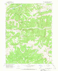
1967 Map of Wolf Creek Summit
USGS Topo · Published 1970About this map
Uinta National Forest lands dominate this high-altitude landscape in the late 1960s, defined by the meeting of several significant watersheds and the path of the historic Old Indian Treaty Boundary. The area serves as a vital hub for water management and forestry, evidenced by the Mill Hollow Reservoir and the Mill Hollow Guard Station. Deep hollows like Shingle Mill Hollow and Telephone Hollow cut through the high ridges, indicating a terrain where natural drainage and early communication routes followed the same steep paths. From the height of Wolf Creek Summit, numerous basins such as Scotty Basin and Jimmies Basin provide alpine catchment for the West Fork Duchesne River and Right Fork Currant Creek. The map also documents the specialized Mill Hollow Granite Sch Center and a high-elevation Pipeline, showing the intersection of conservation, education, and utility infrastructure.
Find a feature on this map
57 named features on this map. Tap any name to fly to it.
Don’t see what you’re looking for? This feature index may not catch every label — zoom into the map to look around manually.
Map Details
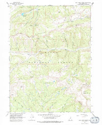
Editions of this 1967 Wolf Creek Summit Map
2 editions found
Other maps of this area

1885 · Salt Lake
USGS Topo · 1:250,000

1885 · Uinta
USGS Topo · 1:250,000

1900 · Coalville
USGS Topo · 1:125,000

1901 · Hayden Peak
USGS Topo · 1:125,000

1903 · Hayden Peak
USGS Topo · 1:125,000

1903 · Coalville
USGS Topo · 1:125,000

1907 · Strawberry Valley
USGS Topo · 1:125,000

1909 · Strawberry Valley
USGS Topo · 1:125,000

1954 · Salt Lake City
USGS Topo · 1:250,000

1958 · Salt Lake City
USGS Topo · 1:250,000