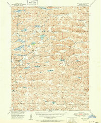
1951 Map of Wolf Lake
USGS Topo · Published 1951About this map
Pullman Valley and the vast ranchlands of Cherry County define this 1951 survey, capturing a landscape of remote cattle operations and numerous sandhill lakes. The territory is marked by the presence of significant holdings like the Pullman Ranch, Coble Ranch, and Roseberry Ranch, illustrating the dominance of the ranching economy in the mid-twentieth century. Educational hubs such as School No 85 and School No 131 are documented alongside specialized sites like Phillips Camp and Kimes Camp, indicating a distributed network of rural community life.
Find a feature on this map
49 named features on this map. Tap any name to fly to it.
Don’t see what you’re looking for? This feature index may not catch every label — zoom into the map to look around manually.
Map Details
Editions of this 1951 Wolf Lake Map
2 editions found

Other maps of this area

1948 · Mullen
USGS Topo · 1:62,500

1948 · Whitman
USGS Topo · 1:62,500

1949 · Big Falls
USGS Topo · 1:62,500

1949 · Steverson Lake
USGS Topo · 1:62,500

1950 · Whitman
USGS Topo · 1:62,500

1950 · Hire
USGS Topo · 1:62,500

1950 · Powderhorn Valley
USGS Topo · 1:62,500

1950 · Doughboy
USGS Topo · 1:62,500

1950 · Wolf Lake
USGS Topo · 1:62,500

1951 · Mullen
USGS Topo · 1:62,500