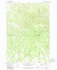
1972 Map of Wolf Mountain
USGS Topo · Published 1985About this map
Wolf Mountain dominates this high-altitude landscape within the Ochoco National Forest, where the borders of Wheeler, Grant, and Crook counties converge. The terrain is defined by a sophisticated network of water management features, including the South Prong Reservoir, Kelsey Reservoir, and Squaw Creek Reservoir, alongside numerous specialized catchments like South Prong Troughs and Mud Reservoir.
Find a feature on this map
65 named features on this map. Tap any name to fly to it.
Don’t see what you’re looking for? This feature index may not catch every label — zoom into the map to look around manually.
Map Details
Editions of this 1972 Wolf Mountain Map
2 editions found
Other maps of this area

1932 · Dayville
USGS Topo · 1:125,000

1936 · Dayville
USGS Topo · 1:125,000

1955 · Canyon City
USGS Topo · 1:250,000

1959 · Canyon City
USGS Topo · 1:250,000

1966 · Antone
USGS Topo · 1:24,000

1966 · Six Corners
USGS Topo · 1:24,000

1972 · Wolf Mountain
USGS Topo · 1:24,000

1972 · Day Basin
USGS Topo · 1:24,000
1972 · Aldrich Gulch
USGS Topo · 1:24,000
1972 · Dayville
USGS Topo · 1:24,000