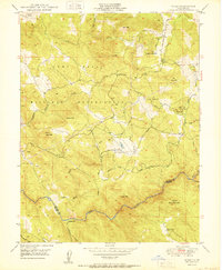
1950 Map of Wolf
USGS Topo · Published 1950About this map
The Camp Beale Military Reservation dominates the western half of this landscape, reflecting a period of significant military land use in Northern California. The terrain is defined by a series of prominent peaks and hills, including Bald Mtn, Iron Mtn, and Bald Rock Mtn, while the southern border is traced by the winding course of the Bear River. This mid-century survey documents the transition from early ranching and mining to modern infrastructure, showing the Pine Hill Mine and scattered small-scale agriculture near Wolf. Water management is a primary feature of the local economy, evidenced by an extensive network of human-made structures like the Ditch, Flume, and Canal that traverse the hillsides. Family and community landmarks, such as Cranston Ranch and Banner Grange, provide essential reference points for genealogists tracing regional history in the Nevada Co and Placer Co borderlands.
Find a feature on this map
39 named features on this map. Tap any name to fly to it.
Don’t see what you’re looking for? This feature index may not catch every label — zoom into the map to look around manually.
Map Details
Editions of this 1950 Wolf Map
2 editions found
Other maps of this area

1888 · Smartsville
USGS Topo · 1:125,000

1891 · Sacramento
USGS Topo · 1:125,000

1891 · Smartsville
USGS Topo · 1:125,000

1892 · Sacramento
USGS Topo · 1:125,000

1892 · Smartsville
USGS Topo · 1:125,000

1893 · Sacramento
USGS Topo · 1:125,000

1894 · Smartsville
USGS Topo · 1:125,000

1895 · Smartsville
USGS Topo · 1:125,000

1910 · Lincoln
USGS Topo · 1:31,680

1915 · Spenceville
USGS Topo · 1:31,680