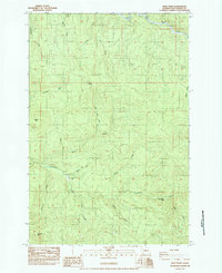
1984 Map of Wolf Point
USGS Topo · Published 1984About this map
The Coweeman River and the South Fork Toutle River define the hydrography of this Washington landscape in the early 1980s. A notable site of historical interest is Camp Coweeman (Site), located along the riverbanks near the junction with Skipper Creek. The terrain is characterized by several named peaks including Wolf Point, Baird Mtn, and Nineteen Mtn, reflecting a region dominated by timber resources and hydraulic features like Washboard Falls. Infrastructure is limited primarily to logging-related markers such as numerous Borrow Pits and the Rose Valley Rd access point. The map illustrates a transitional period for the Pacific Northwest forest lands, documenting a topography shaped by both natural drainage systems like Little Baird Creek and industrial activity within designated Private holdings.
Find a feature on this map
24 named features on this map. Tap any name to fly to it.
Don’t see what you’re looking for? This feature index may not catch every label — zoom into the map to look around manually.
Map Details
Editions of this 1984 Wolf Point Map
2 editions found
Other maps of this area

1919 · Mount St Helens
USGS Topo · 1:125,000

1942 · Toutle
USGS Topo · 1:62,500

1943 · Pigeon Springs
USGS Topo · 1:62,500

1953 · Hoquiam
USGS Topo · 1:250,000

1953 · Toutle
USGS Topo · 1:62,500

1953 · Pigeon Springs
USGS Topo · 1:62,500

1953 · Cougar
USGS Topo · 1:62,500

1953 · Elk Rock
USGS Topo · 1:62,500

1957 · Hoquiam
USGS Topo · 1:250,000

1958 · Hoquiam
USGS Topo · 1:250,000