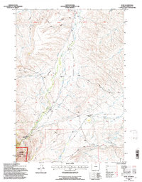
1993 Map of Wolf
USGS Topo · Published 1997About this map
Wolf Creek and its complex network of tributaries, including East Wolf Creek and Dye Shields Creek, define the drainage patterns of this Sheridan County landscape. The mapping reflects a region where water management is critical to ranching and local life, evidenced by the presence of the South Side Ditch, Alliance Ditch, and Hanff Reservoir. Human settlement is centered around established family and commercial holdings such as the P K Ranch and the community of Wolf, while the higher elevations are protected within the Bighorn National Forest.
Find a feature on this map
33 named features on this map. Tap any name to fly to it.
Don’t see what you’re looking for? This feature index may not catch every label — zoom into the map to look around manually.
Map Details
Editions of this 1993 Wolf Map
This is the sole edition of this map. No revisions or reprints were ever made.
Other maps of this area

1895 · Dayton
USGS Topo · 1:125,000

1901 · Dayton
USGS Topo · 1:125,000

1955 · Sheridan
USGS Topo · 1:250,000

1958 · Sheridan
USGS Topo · 1:250,000

1962 · Sheridan
USGS Topo · 1:250,000

1964 · Wolf
USGS Topo · 1:24,000
1964 · Ranchester
USGS Topo · 1:24,000
1964 · Dayton North
USGS Topo · 1:24,000
1964 · Monarch
USGS Topo · 1:24,000

1964 · Dayton South
USGS Topo · 1:24,000