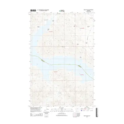
2014 Map of Wolfe Coulee
USGS Topo · Published 2014About this map
The Missouri River bisects this landscape, marking the natural boundary between Valley and Garfield counties. This 2014 survey documents a rugged, drainage-heavy terrain defined by deep erosional features like Hell Hole Coulee and Cut Throat Coulee. The topography north of the river is particularly intricate, where Wyatt Coulee and Wolfe Coulee channel toward the river valley. Human infrastructure is sparse in this portion of the northern plains, with Burke Ranch Rd and primitive routes like NF-326 providing the primary access to these remote breaks. South of the river, the map shows the winding course of Billy Cr and the expansive Billy Coulee, illustrating the complex drainage systems that feed into the Missouri.
Find a feature on this map
20 named features on this map. Tap any name to fly to it.
Don’t see what you’re looking for? This feature index may not catch every label — zoom into the map to look around manually.
Map Details
Editions of this 2014 Wolfe Coulee Map
This is the sole edition of this map. No revisions or reprints were ever made.
Other maps of this area

1954 · Jordan
USGS Topo · 1:250,000

1956 · Jordan
USGS Topo · 1:250,000

1958 · Jordan
USGS Topo · 1:250,000

1964 · Jordan
USGS Topo · 1:250,000

1971 · Hell Hollow
USGS Topo · 1:24,000

1971 · Wolfe Coulee
USGS Topo · 1:24,000

1971 · Wagon Coulee
USGS Topo · 1:24,000

1971 · Sawmill Creek
USGS Topo · 1:24,000

1971 · Chalk Butte
USGS Topo · 1:24,000
1971 · Swede Ridge
USGS Topo · 1:24,000