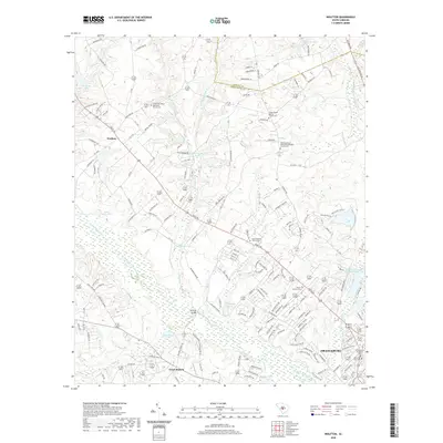
2020 Map of Wolfton
USGS Topo · Published 2020About this map
The North Fork Edisto River meanders through this portion of the South Carolina Midlands, defining a landscape of low-lying wetlands and agricultural upland between Wolfton and the northwest periphery of Orangeburg. This modern survey illustrates a territory deeply connected to its denominational roots, featuring numerous congregational landmarks such as Limestone United Methodist Church and the Calvary African Methodist Episcopal Church. The transition from rural creek bottoms like Caw Caw Swamp and Little Limestone Creek to the developing residential outskirts of Orangeburg is clear. Notable water features, including the Wannamaker Catfish Ponds and John Smiths Pond, highlight the importance of aquaculture and local hydrology, while the prominent Craggy Bluff overlooking Great Branch provides a rare point of elevation in the riverine terrain.
Find a feature on this map
204 named features on this map. Tap any name to fly to it.
Don’t see what you’re looking for? This feature index may not catch every label — zoom into the map to look around manually.
Map Details
Editions of this 2020 Wolfton Map
This is the sole edition of this map. No revisions or reprints were ever made.
Other maps of this area

1919 · Bamberg
USGS Topo · 1:48,000

1920 · Bamberg
USGS Topo · 1:62,500

1920 · Orangeburg
USGS Topo · 1:48,000

1921 · Orangeburg
USGS Topo · 1:62,500

1943 · Bamberg
USGS Topo · 1:62,500

1943 · Orangeburg
USGS Topo · 1:125,000

1943 · Orangeburg
USGS Topo · 1:62,500

1946 · Woodford
USGS Topo · 1:62,500

1946 · St. Matthews
USGS Topo · 1:62,500

1954 · Augusta
USGS Topo · 1:250,000