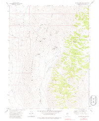
1972 Map of Wonder Mountain
USGS Topo · Published 1987About this map
The rugged mining landscapes of Churchill County are preserved in this 1972 survey, centered on the historic district surrounding Wonder Mountain. The map identifies the ghost sites of Victor, Hercules, and Wonder, once-bustling mining camps that thrived during the Nevada silver and gold booms. The presence of Wonder Mine and extensive Tailings marks the industrial legacy of the area, while a lonely Cem remains as a quiet marker of the community that once resided here.
Find a feature on this map
25 named features on this map. Tap any name to fly to it.
Don’t see what you’re looking for? This feature index may not catch every label — zoom into the map to look around manually.
Map Details
Editions of this 1972 Wonder Mountain Map
3 editions found
Other maps of this area

1908 · Carson Sink
USGS Topo · 1:250,000

1910 · Carson Sink
USGS Topo · 1:250,000

1955 · Millett
USGS Topo · 1:250,000

1957 · Reno
USGS Topo · 1:250,000

1959 · Reno
USGS Topo · 1:250,000

1959 · Millett
USGS Topo · 1:250,000

1960 · Reno
USGS Topo · 1:250,000

1966 · Clan Alpine Ranch
USGS Topo · 1:62,500

1969 · Camp Creek Canyon
USGS Topo · 1:24,000

1969 · Eastgate
USGS Topo · 1:24,000