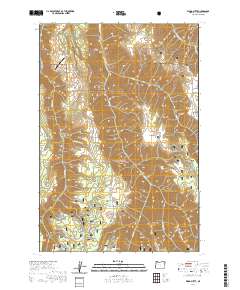
2020 Map of Wood Butte
USGS Topo · Published 2020About this map
Wallowa National Forest land dominates this section of the Oregon high country, characterized by a series of prominent finger ridges and deep canyons. The terrain is structured around north-south features like Powwatka Ridge, which hosts the Powwatka Ridge Airport at its northern end, and the namesake Wood Butte. This landscape is defined by its drainage network, where Wildcat Cr and Mud Cr have carved significant relief into the plateau. The placement of Troy Rd and Day Ridge Rd follows the natural contours of the high ground, a common pattern in the Pacific Northwest where topography dictates transportation. Small landmarks like the Waterhole near Kuhn Canyon point to the area's utility for livestock or local wildlife management within the protected forest boundaries.
Find a feature on this map
32 named features on this map. Tap any name to fly to it.
Don’t see what you’re looking for? This feature index may not catch every label — zoom into the map to look around manually.
Map Details
Editions of this 2020 Wood Butte Map
This is the sole edition of this map. No revisions or reprints were ever made.
Other maps of this area

1955 · Grangeville
USGS Topo · 1:250,000

1957 · Sled Springs
USGS Topo · 1:62,500

1959 · Grangeville
USGS Topo · 1:250,000

1964 · Akers Butte
USGS Topo · 1:24,000

1967 · Wood Butte
USGS Topo · 1:24,000

1967 · Troy
USGS Topo · 1:24,000

1967 · Eden
USGS Topo · 1:24,000
1967 · Shamrock Creek
USGS Topo · 1:24,000

1967 · Promise
USGS Topo · 1:24,000
1967 · Flora
USGS Topo · 1:24,000