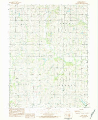
1983 Map of Wood
USGS Topo · Published 1984About this map
Lost Creek and the Little Third Fork define the drainage patterns of this rural landscape in western Missouri during the early 1980s. The area is organized into four distinct townships: Polk, Grant, Sherman, and Camden. At the center of this agricultural network sits the small community of Wood, a focal point for the surrounding farmsteads. Family history and local heritage are well-preserved through several scattered burial grounds including Butler Cem, Smith Cem, Botts Cem, and Sharp Cem. The map reveals a highly structured grid of section lines and rural roads, typical of the Midwestern prairie, punctuated by community gathering places like Faith Chapel. In the southern reaches, Castile Cr flows toward a Spillway, indicating water management efforts within this rolling terrain.
Find a feature on this map
14 named features on this map. Tap any name to fly to it.
Don’t see what you’re looking for? This feature index may not catch every label — zoom into the map to look around manually.
Map Details
Editions of this 1983 Wood Map
This is the sole edition of this map. No revisions or reprints were ever made.
Other maps of this area

1923 · Clarksdale
USGS Topo · 1:62,500

1923 · Maysville
USGS Topo · 1:62,500

1925 · Clarksdale
USGS Topo · 1:62,500

1925 · Stanberry
USGS Topo · 1:62,500

1925 · Maysville
USGS Topo · 1:62,500

1925 · Darlington
USGS Topo · 1:62,500

1939 · Stanberry
USGS Topo · 1:62,500

1943 · Stanberry
USGS Topo · 1:62,500

1950 · Kansas City
USGS Topo · 1:250,000

1950 · Darlington
USGS Topo · 1:62,500