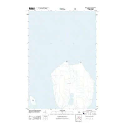
2012 Map of Wood Island
USGS Topo · Published 2012About this map
Grand Island dominates this maritime survey, illustrating the northern reaches of Alger County's island geography within Lake Superior. The interior of the island reveals a complex hydrology centered on Echo Lake, which drains southward via Echo Lake Cr. The northern coastline is defined by several prominent projections, including Gull Point, North Point, and Northeast Point, while the smaller Wood Island sits to the southwest. A network of forest roads and trails traces the island's interior, providing access to the watershed of North Light Cr and the diverse shoreline topography. The map detail indicates a landscape managed for natural preservation and recreational transit, with specific forest service data identifying high-clearance and passenger routes through the timbered interior.
Find a feature on this map
9 named features on this map. Tap any name to fly to it.
Don’t see what you’re looking for? This feature index may not catch every label — zoom into the map to look around manually.
Map Details
Editions of this 2012 Wood Island Map
This is the sole edition of this map. No revisions or reprints were ever made.
Other maps of this area

1958 · Munising
USGS Topo · 1:62,500

1958 · Au Train
USGS Topo · 1:62,500

1958 · Wood Island
USGS Topo · 1:62,500

1958 · Marquette
USGS Topo · 1:250,000

1960 · Marquette
USGS Topo · 1:250,000

1961 · Marquette
USGS Topo · 1:250,000

1968 · Marquette
USGS Topo · 1:250,000

1983 · Munising
USGS Topo · 1:100,000
1984 · Au Sable Point
USGS Topo · 1:100,000
1984 · Wood Island SE
USGS Topo · 1:24,000