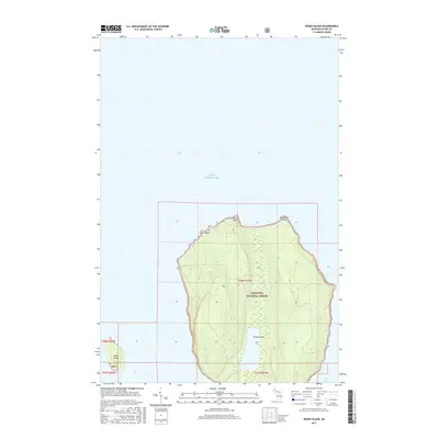
2017 Map of Wood Island
USGS Topo · Published 2017About this map
Grand Island dominates this portion of the Lake Superior coastline, its landforms protected within the Hiawatha National Forest. This 2017 survey details the complex shoreline of the island's northern reaches, including the prominent North Point, Northeast Point, and Gull Point. To the west, the smaller landmass of Wood Island sits isolated in the open waters of Lake Superior, providing a clear record of the area's maritime geography. The southeastern edge of the map captures the sheltered Trout Bay, showing the interplay between the deep waters and the coastal forest. Topographic contours reveal the elevation changes across the interior of the main island, which is largely uninhabited except for forest service management, as indicated by the HNF boundary labels. The map provides a high-resolution view of these landforms before further environmental or administrative changes.
Find a feature on this map
13 named features on this map. Tap any name to fly to it.
Don’t see what you’re looking for? This feature index may not catch every label — zoom into the map to look around manually.
Map Details
Editions of this 2017 Wood Island Map
This is the sole edition of this map. No revisions or reprints were ever made.
Other maps of this area

1958 · Munising
USGS Topo · 1:62,500

1958 · Au Train
USGS Topo · 1:62,500

1958 · Wood Island
USGS Topo · 1:62,500

1958 · Marquette
USGS Topo · 1:250,000

1960 · Marquette
USGS Topo · 1:250,000

1961 · Marquette
USGS Topo · 1:250,000

1968 · Marquette
USGS Topo · 1:250,000

1983 · Munising
USGS Topo · 1:100,000
1984 · Au Sable Point
USGS Topo · 1:100,000
1984 · Wood Island SE
USGS Topo · 1:24,000