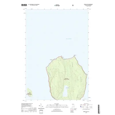
2019 Map of Wood Island
USGS Topo · Published 2019About this map
Grand Island and the smaller Wood Island dominate this coastal survey of Alger County, Michigan. Protected as part of the Hiawatha National Forest, the interior of the islands features dense wetland networks and high-elevation ridges characteristic of the Lake Superior shoreline. The mapping details a deliberate recreational infrastructure, specifically the Grand Island Bike path and the Grand Island Hike Only E trail, which circumnavigate the island's perimeter. Distinct geographical features such as Gull Point, North Point, and Northeast Point define the rugged northern exposure, while the southeast coast curves inward to form the sheltered Trout Bay. This 2019 survey documents the landscape's transition from a historical island community to a managed national forest environment, emphasizing primitive transport routes over modern road systems.
Find a feature on this map
14 named features on this map. Tap any name to fly to it.
Don’t see what you’re looking for? This feature index may not catch every label — zoom into the map to look around manually.
Map Details
Editions of this 2019 Wood Island Map
This is the sole edition of this map. No revisions or reprints were ever made.
Other maps of this area

1958 · Munising
USGS Topo · 1:62,500

1958 · Au Train
USGS Topo · 1:62,500

1958 · Wood Island
USGS Topo · 1:62,500

1958 · Marquette
USGS Topo · 1:250,000

1960 · Marquette
USGS Topo · 1:250,000

1961 · Marquette
USGS Topo · 1:250,000

1968 · Marquette
USGS Topo · 1:250,000

1983 · Munising
USGS Topo · 1:100,000
1984 · Au Sable Point
USGS Topo · 1:100,000
1984 · Wood Island SE
USGS Topo · 1:24,000