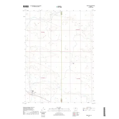
2017 Map of Wood Lake
USGS Topo · Published 2017About this map
Wood Lake serves as the primary settlement on this Nebraska landscape, characterized by the distinct drainages of the Sandhills region. The town is situated in the southwestern portion of the map, where Lake St and Main St form the local street grid near the railroad corridor. Just east of the residential area lies Mount Hope Cem, a key landmark for genealogical research. The surrounding terrain is defined by low-lying valleys and intermittent watercourses, including the winding path of Evergreen Cr and the seasonal flow of Dry Cr. To the north, the S Fork Fairfield Cr cuts through the open country, while Porter Valley provides a notable topographical depression in the eastern section of the quadrangle. The map captures the sparse, rural settlement pattern typical of Cherry County, where local roads like RD e89 provide vital connections between isolated ranches and the village center.
Find a feature on this map
14 named features on this map. Tap any name to fly to it.
Don’t see what you’re looking for? This feature index may not catch every label — zoom into the map to look around manually.
Map Details
Editions of this 2017 Wood Lake Map
This is the sole edition of this map. No revisions or reprints were ever made.
Other maps of this area

1950 · Norden
USGS Topo · 1:62,500

1950 · Sparks
USGS Topo · 1:62,500

1950 · Wood Lake
USGS Topo · 1:62,500

1950 · Arabia
USGS Topo · 1:62,500

1952 · Norden
USGS Topo · 1:62,500

1957 · Valentine
USGS Topo · 1:250,000

1959 · Valentine
USGS Topo · 1:250,000
1983 · Norden
USGS Topo · 1:24,000
1983 · Muleshoe Creek
USGS Topo · 1:24,000
1983 · Sparks SE
USGS Topo · 1:24,000