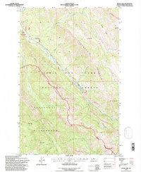
1995 Map of Wood Lake
USGS Topo · Published 1997About this map
The Sawtooth Range dominates this mid-1990s terrain, where the remote Lewis and Clark National Forest meets the high peaks of the Scapegoat Wilderness. This map reveals a landscape defined by sharp ridges and deep creek drainages, anchored by the Benchmark Wilderness Ranch and the adjacent Benchmark Airfield, which serve as critical access points for this part of the Montana backcountry. The topographic survey highlights dramatic elevations ranging from Fairview Mountain to the prominent ridge of the Hogback. The presence of the Van De Riet Memorial near the airfield and a Boat Landing at Wood Lake indicates the area's significance for recreation and memorialization. Tracing the numerous drainages like Wood Creek and Straight Creek reveals the complex hydrology that feeds into the higher-altitude Alpine Lake and the rugged Crown Mountain area.
Find a feature on this map
40 named features on this map. Tap any name to fly to it.
Don’t see what you’re looking for? This feature index may not catch every label — zoom into the map to look around manually.
Map Details
Editions of this 1995 Wood Lake Map
This is the sole edition of this map. No revisions or reprints were ever made.
Other maps of this area

1903 · Saypo
USGS Topo · 1:125,000

1903 · Coopers Lake
USGS Topo · 1:125,000

1955 · Choteau
USGS Topo · 1:250,000

1957 · Choteau
USGS Topo · 1:250,000

1958 · Choteau
USGS Topo · 1:250,000

1958 · Sawtooth Ridge
USGS Topo · 1:24,000

1958 · Pretty Prairie
USGS Topo · 1:24,000

1958 · Patricks Basin
USGS Topo · 1:24,000

1962 · Choteau
USGS Topo · 1:250,000
1970 · Scapegoat Mountain
USGS Topo · 1:24,000