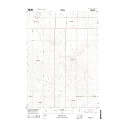
2015 Map of Wood South
USGS Topo · Published 2015About this map
Wood is located at the northern edge of this South Dakota landscape, serving as a focal point for the surrounding prairie. The area is characterized by the winding path of Butte Cr, which drains toward the north through a series of sections defined by the Public Land Survey System. Genealogical interest is centered on the town's outskirts, where Evergreen Cem and Mediator Cem are established, providing a record of early residents in this part of Mellette County. To the southeast, the terrain rises to Rattlesnake Butte, a prominent landmark that breaks the steady elevation of the plains. The map illustrates a rural network of section-line roads, including 283rd Ave and 274th St, and marks the administrative transition at the boundary of Mellette Co and Todd Co.
Find a feature on this map
25 named features on this map. Tap any name to fly to it.
Don’t see what you’re looking for? This feature index may not catch every label — zoom into the map to look around manually.
Map Details
Editions of this 2015 Wood South Map
This is the sole edition of this map. No revisions or reprints were ever made.
Other maps of this area

1955 · Martin
USGS Topo · 1:250,000

1958 · Martin
USGS Topo · 1:250,000

1982 · Mission NE
USGS Topo · 1:24,000

1982 · White River SE
USGS Topo · 1:24,000

1982 · Wood North
USGS Topo · 1:24,000

1982 · Badnation SE
USGS Topo · 1:25,000

1982 · Okreek
USGS Topo · 1:25,000

1982 · Okreek SE
USGS Topo · 1:24,000
1982 · Mission SE
USGS Topo · 1:24,000

1982 · Mosher
USGS Topo · 1:25,000