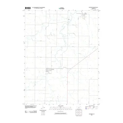
2009 Map of Woodbine
USGS Topo · Published 2009About this map
Woodbine serves as the primary hub of this Dickinson County landscape, situated where the local road network converges near the banks of Lyon Creek. The town's layout is defined by its agricultural and transit heritage, visible in the alignment of E Railway Ave and the proximity of Woodbine Cemetery on the western edge of the settlement. The surrounding terrain is deeply carved by the serpentine path of the creek and its tributaries, including Carry Creek and the West Branch, which dictate the rural property boundaries and the placement of remote settlements like Lyona. To the north, the landscape shifts toward recreational and ranching uses, anchored by the presence of Camp-Wa-shun-ga and the sprawling Rock Springs Ranch. This survey reflects a modern era of Kansas land management where ancient watercourses still heavily influence the grid of avenues and roads such as Wolf Rd and Vane Rd.
Find a feature on this map
31 named features on this map. Tap any name to fly to it.
Don’t see what you’re looking for? This feature index may not catch every label — zoom into the map to look around manually.
Map Details
Editions of this 2009 Woodbine Map
This is the sole edition of this map. No revisions or reprints were ever made.
Other maps of this area

1889 · Abilene
USGS Topo · 1:125,000

1889 · Parkerville
USGS Topo · 1:125,000

1894 · Abilene
USGS Topo · 1:125,000

1894 · Parkerville
USGS Topo · 1:125,000

1955 · Hutchinson
USGS Topo · 1:250,000

1959 · Hutchinson
USGS Topo · 1:250,000
1964 · Chapman
USGS Topo · 1:24,000

1964 · Navarre
USGS Topo · 1:24,000

1964 · Skiddy
USGS Topo · 1:24,000
1964 · Kansas Falls
USGS Topo · 1:24,000