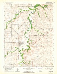
1964 Map of Woodbine
USGS Topo · Published 1966About this map
Woodbine serves as the central hub for this portion of the Kansas plains, situated along the Chicago Rock Island and Pacific railroad. The settlement pattern is defined by the winding paths of Carry Creek and Lyon Creek, which converge in a landscape marked by agrarian townships like Rinehart, Liberty, and Overland. Local education and community life are anchored at the Carry Creek Sch and the local Woodbine Cem, while the northern reaches of the quadrangle feature specialized recreational and organizational sites including Rock Springs Ranch and Camp Wa-shun-ga. The terrain's natural resources are evident in several scattered Quarries and Gravel Pits, pointing to a local economy grounded in both agriculture and stone extraction during the mid-1960s.
Find a feature on this map
27 named features on this map. Tap any name to fly to it.
Don’t see what you’re looking for? This feature index may not catch every label — zoom into the map to look around manually.
Map Details
Editions of this 1964 Woodbine Map
This is the sole edition of this map. No revisions or reprints were ever made.
Other maps of this area

1889 · Abilene
USGS Topo · 1:125,000

1889 · Parkerville
USGS Topo · 1:125,000

1894 · Abilene
USGS Topo · 1:125,000

1894 · Parkerville
USGS Topo · 1:125,000

1955 · Hutchinson
USGS Topo · 1:250,000

1959 · Hutchinson
USGS Topo · 1:250,000
1964 · Chapman
USGS Topo · 1:24,000

1964 · Navarre
USGS Topo · 1:24,000

1964 · Skiddy
USGS Topo · 1:24,000
1964 · Kansas Falls
USGS Topo · 1:24,000