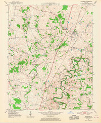
1951 Map of Woodburn
USGS Topo · Published 1968About this map
Woodburn serves as the primary hub of this South-Central Kentucky landscape, where the Louisville and Nashville railroad cuts a straight path through the limestone-rich terrain of the Pennyroyal Plateau. The map reveals a community structured around civic and religious institutions, including the Woodburn Sch, Old Zion Ch, and the Stevenson Ch. The presence of the County Home and Methodist Home suggests a regional center for social services during the mid-twentieth century. To the east and south, the meandering curves of Drakes Creek and the West Fork Drakes Creek create a stark contrast to the linear rail corridor, while features like Sinking Creek and local Quarry sites hint at the karst geology that defines the Warren and Simpson County border. Smaller settlements such as Salmons and Black Jack anchor the southern reaches of the survey.
Find a feature on this map
18 named features on this map. Tap any name to fly to it.
Don’t see what you’re looking for? This feature index may not catch every label — zoom into the map to look around manually.
Map Details
Editions of this 1951 Woodburn Map
2 editions found
Other maps of this area

1921 · Bowling Green
USGS Topo · 1:62,500

1923 · Bowling Green
USGS Topo · 1:62,500

1928 · Adolphus
USGS Topo · 1:48,000

1931 · Adolphus
USGS Topo · 1:62,500

1942 · Gallatin
USGS Topo · 1:100,000

1951 · Woodburn
USGS Topo · 1:24,000

1951 · Franklin
USGS Topo · 1:24,000

1951 · Prices Mill
USGS Topo · 1:24,000

1951 · Auburn
USGS Topo · 1:24,000

1951 · South Union
USGS Topo · 1:24,000