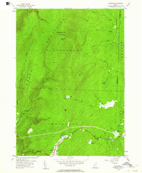
1954 Map of Woodford
USGS Topo · Published 1961About this map
Glastenbury Mtn dominates the landscape of the southern Green Mountains, its summit marked by a lookout tower and the high-elevation Glastenbury Camp. The 1954 field check by the Geological Survey documents a wilderness shaped by water and primitive routes, where the Long Trail traverses the ridgeline and connects with the Stark Trail. To the south, the settlement of Woodford sits near the banks of City Stream, surrounded by a network of basins including Big Pond, Adams Reservoir, and Red Mill Pond. This era shows a high-country economy transition, with markers like Bickford Dam and the Kelly Camp Trail indicating historic resource management and recreation within the National Forest. The intricate drainage patterns of Somerset River and Bolles Brook define the deep hollows and meadows that have challenged and supported Vermont mountain communities for generations.
Find a feature on this map
43 named features on this map. Tap any name to fly to it.
Don’t see what you’re looking for? This feature index may not catch every label — zoom into the map to look around manually.
Map Details
Editions of this 1954 Woodford Map
3 editions found

Other maps of this area

1889 · Wilmington
USGS Topo · 1:62,500

1891 · Wilmington
USGS Topo · 1:62,500

1894 · Londonderry
USGS Topo · 1:62,500

1894 · Equinox
USGS Topo · 1:62,500

1896 · Equinox
USGS Topo · 1:62,500

1898 · Bennington
USGS Topo · 1:62,500

1899 · Londonderry
USGS Topo · 1:62,500

1899 · Wilmington
USGS Topo · 1:62,500

1900 · Taconic
USGS Topo · 1:125,000

1900 · Equinox
USGS Topo · 1:62,500