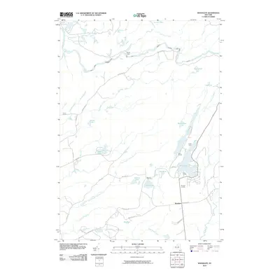
2010 Map of Woodgate
USGS Topo · Published 2010About this map
White Lake and the surrounding Adirondack foothills define the landscape of this 2010 survey. The area is characterized by a high concentration of recreational and institutional camps, including the Masonic Home Camp, Camp Nazareth, and Camp Russell, all situated near the water's edge. The settlement of Woodgate serves as a central hub, where Bear Creek Rd meets the main thoroughfare. Further south, the Woodgate Cemetery stands as a primary genealogical resource for the community.
Find a feature on this map
46 named features on this map. Tap any name to fly to it.
Don’t see what you’re looking for? This feature index may not catch every label — zoom into the map to look around manually.
Map Details
Editions of this 2010 Woodgate Map
This is the sole edition of this map. No revisions or reprints were ever made.
Other maps of this area

1897 · Remsen
USGS Topo · 1:62,500

1900 · Remsen
USGS Topo · 1:62,500

1904 · Boonville
USGS Topo · 1:62,500

1905 · Port Leyden
USGS Topo · 1:62,500

1907 · Port Leyden
USGS Topo · 1:62,500

1912 · Mc Keever
USGS Topo · 1:62,500

1940 · Port Leyden
USGS Topo · 1:62,500

1945 · Boonville
USGS Topo · 1:24,000

1945 · Forestport
USGS Topo · 1:24,000
1946 · North Wilmurt
USGS Topo · 1:24,000