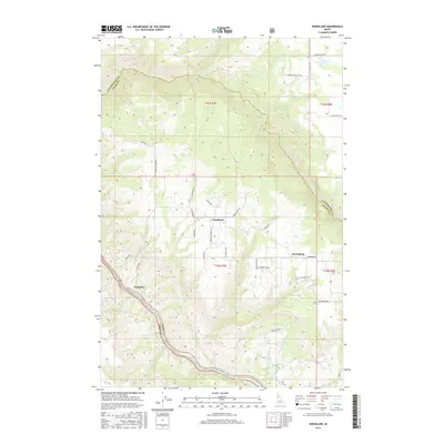
2017 Map of Woodland
USGS Topo · Published 2017About this map
Clearwater River canyon walls define the southwestern boundary of this Idaho landscape, where the waterway carves a deep path between Idaho and Lewis counties. On the high plateau above the river, the small settlements of Woodland and Harrisburg serve as local hubs for a rural network of ridges and gulches. The terrain is deeply dissected by drainage systems like Lolo Creek and Schmidt Cr, creating a complex series of fingers and draws. Local names etched into the geography, such as Schmidt Mill Rd, Mc Goldrick Ln, and Pucketts Corner Rd, suggest a long history of family homesteading and timber activity. This 2017 survey details the enduring agricultural and forest-access routes, from Carrot Ridge Rd to the curious Poverty Gulch Rd, reflecting the high-country lifestyle of the Camas Prairie region.
Find a feature on this map
38 named features on this map. Tap any name to fly to it.
Don’t see what you’re looking for? This feature index may not catch every label — zoom into the map to look around manually.
Map Details
Editions of this 2017 Woodland Map
This is the sole edition of this map. No revisions or reprints were ever made.
Other maps of this area

1924 · Kamiah
USGS Topo · 1:125,000

1924 · Weippe
USGS Topo · 1:125,000

1955 · Pullman
USGS Topo · 1:250,000

1956 · Hamilton
USGS Topo · 1:250,000

1958 · Pullman
USGS Topo · 1:250,000

1959 · Hamilton
USGS Topo · 1:250,000

1960 · Hamilton
USGS Topo · 1:250,000

1964 · Hamilton
USGS Topo · 1:250,000

1966 · Kooskia
USGS Topo · 1:24,000
1966 · Weippe South
USGS Topo · 1:24,000