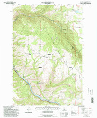
1994 Map of Woodland
USGS Topo · Published 1998About this map
Woodland and Harrisburg sit atop the high plateaus of the Nez Perce Indian Reservation in this mid-1990s survey. The landscape is defined by the deep carving of the Clearwater River, which forms a significant county boundary at the southwest edge of the map. Along the river's banks, small settlements like Pardee and Tramway are situated near the steep canyon walls, while the upland areas are dotted with small farming communities and a local Cem.
Find a feature on this map
17 named features on this map. Tap any name to fly to it.
Don’t see what you’re looking for? This feature index may not catch every label — zoom into the map to look around manually.
Map Details
Editions of this 1994 Woodland Map
This is the sole edition of this map. No revisions or reprints were ever made.
Other maps of this area

1924 · Kamiah
USGS Topo · 1:125,000

1924 · Weippe
USGS Topo · 1:125,000

1955 · Pullman
USGS Topo · 1:250,000

1956 · Hamilton
USGS Topo · 1:250,000

1958 · Pullman
USGS Topo · 1:250,000

1959 · Hamilton
USGS Topo · 1:250,000

1960 · Hamilton
USGS Topo · 1:250,000

1964 · Hamilton
USGS Topo · 1:250,000

1966 · Kooskia
USGS Topo · 1:24,000
1966 · Weippe South
USGS Topo · 1:24,000