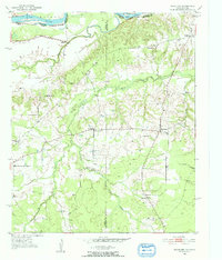
1951 Map of Woodland
USGS Topo · Published 1952About this map
The Red River and Wilson River form the northern boundary of this Northeast Texas landscape, where the borders of Lamar, Red River, and Choctaw counties converge. The terrain is defined by the winding course of Little Pine Creek and Pecan Bayou, supporting a network of small agricultural settlements. In the early 1950s, the community of Woodland served as a local hub, anchored by the Woodland Cem and nearby Tinsley Cem. Further west, the settlement of Faulkner is marked by a concentration of local institutions, including Faulkner Ch and Faulkner Cem. This survey preserves the locations of rural schoolhouses and churches that served the area's farming families, such as Ward Sch, Lone Star Sch, and Hickory Hill Ch, providing a detailed view of the social fabric before later 20th-century consolidation.
Find a feature on this map
21 named features on this map. Tap any name to fly to it.
Don’t see what you’re looking for? This feature index may not catch every label — zoom into the map to look around manually.
Map Details
Editions of this 1951 Woodland Map
2 editions found
Other maps of this area

1951 · Slate Shoals
USGS Topo · 1:24,000

1951 · Frogville
USGS Topo · 1:24,000

1951 · Shoals
USGS Topo · 1:24,000

1951 · Kiomatia
USGS Topo · 1:24,000

1951 · Woodland
USGS Topo · 1:24,000

1951 · Manchester
USGS Topo · 1:24,000

1953 · Texarkana
USGS Topo · 1:250,000

1956 · Texarkana
USGS Topo · 1:250,000

1964 · Detroit
USGS Topo · 1:24,000

1964 · Bagwell
USGS Topo · 1:24,000