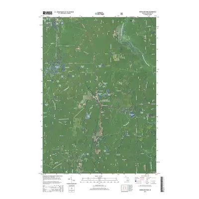
2014 Map of Woodland Park
USGS Topo · Published 2014About this map
The Manistee National Forest provides a vast wooded backdrop for this portion of Newaygo County, where the landscape is defined by an intricate network of glacial lakes and small watercourses. Settlements like Woodland Park and Brohman are centered around these water bodies, which include Woodland Lake, Bluegill Lake, and Loda Lake. The map reveals a balance between conservation and local history, as seen in the winding path of the N Country National Scenic Trail and the presence of several community anchors like the Merrill Township Cem and Hillers Cem. In the north, Bitely sits near the headwaters of the Little S Br Pere Marquette River, highlighting the area's importance for regional drainage. The road network, including State Hwy 37, connects these small hubs, tracing the high ground around landmarks like Skidder Hill.
Find a feature on this map
81 named features on this map. Tap any name to fly to it.
Don’t see what you’re looking for? This feature index may not catch every label — zoom into the map to look around manually.
Map Details
Editions of this 2014 Woodland Park Map
This is the sole edition of this map. No revisions or reprints were ever made.
Other maps of this area

1954 · Midland
USGS Topo · 1:250,000

1958 · Midland
USGS Topo · 1:250,000

1958 · Woodville
USGS Topo · 1:62,500

1959 · Midland
USGS Topo · 1:250,000

1959 · Reed City
USGS Topo · 1:62,500

1959 · Baldwin
USGS Topo · 1:62,500

1959 · White Cloud
USGS Topo · 1:62,500

1966 · Midland
USGS Topo · 1:250,000
1976 · White Cloud SW
USGS Topo · 1:24,000
1976 · Baldwin SE
USGS Topo · 1:24,000