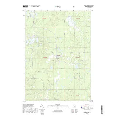
2019 Map of Woodland Park
USGS Topo · Published 2019About this map
Manistee National Forest encompasses the majority of this landscape in Newaygo County, characterized by a dense network of glacial lakes and small settlements. The community of Woodland Park serves as a central hub near East Lake, while Bitely sits to the north and Brohman to the south along the primary roadway corridor. This area reflects a long-standing recreation and timber legacy, evident in the numerous named water bodies like Bluegill Lake, Richmond Lake, and the designated wildflower sanctuary at Loda Lake. The map provides significant genealogical value through its marking of local burial grounds, including Merrill Township Cem, Hillers Cem, and Saint Joseph's Catholic Cem. Between these points of interest, the terrain transitions from the wetlands of Blue Lake Drain to the elevated ground of Skidder Hill, illustrating the complex drainage patterns that feed the Little S Br Pere Marquette River.
Find a feature on this map
95 named features on this map. Tap any name to fly to it.
Don’t see what you’re looking for? This feature index may not catch every label — zoom into the map to look around manually.
Map Details
Editions of this 2019 Woodland Park Map
This is the sole edition of this map. No revisions or reprints were ever made.
Other maps of this area

1954 · Midland
USGS Topo · 1:250,000

1958 · Midland
USGS Topo · 1:250,000

1958 · Woodville
USGS Topo · 1:62,500

1959 · Midland
USGS Topo · 1:250,000

1959 · Reed City
USGS Topo · 1:62,500

1959 · Baldwin
USGS Topo · 1:62,500

1959 · White Cloud
USGS Topo · 1:62,500

1966 · Midland
USGS Topo · 1:250,000
1976 · White Cloud SW
USGS Topo · 1:24,000
1976 · Baldwin SE
USGS Topo · 1:24,000