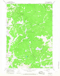
1964 Map of Woodrock
USGS Topo · Published 1968About this map
The Bighorn National Forest interior, spanning the Sheridan and Big Horn county line, is characterized here by its high-altitude resource management and seasonal livestock heritage. The presence of Padlock Cow Camp and the Woodrock Guard Sta reflects the administrative and ranching history of the region in the mid-1960s. The landscape is a complex drainage system defined by the South Tongue River and its many tributaries, including Copper Creek and Sucker Creek.
Find a feature on this map
38 named features on this map. Tap any name to fly to it.
Don’t see what you’re looking for? This feature index may not catch every label — zoom into the map to look around manually.
Map Details
Editions of this 1964 Woodrock Map
2 editions found
Other maps of this area

1895 · Dayton
USGS Topo · 1:125,000

1898 · Bald Mountain
USGS Topo · 1:125,000

1901 · Dayton
USGS Topo · 1:125,000

1901 · Bald Mountain
USGS Topo · 1:125,000

1955 · Sheridan
USGS Topo · 1:250,000

1958 · Sheridan
USGS Topo · 1:250,000

1960 · Shell Falls
USGS Topo · 1:24,000

1960 · Granite Pass
USGS Topo · 1:24,000

1962 · Sheridan
USGS Topo · 1:250,000
1964 · Burgess Junction
USGS Topo · 1:24,000