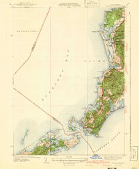
1941 Map of Woods Hole
USGS Topo · Published 1941About this map
The southwestern tip of Cape Cod is defined by the intricate coastline of Woods Hole and the upper Elizabeth Islands, where the waters of Buzzards Bay meet the Vineyard Sound. This 1941 edition shows the area's transition from a maritime and agricultural landscape to a seasonal destination, featuring the expansive Woods Hole Golf Club and the Falmouth Country Club. The rail infrastructure of the New York New Haven and Hartford railroad tracks the shoreline, connecting West Falmouth to the busy harbors. Natural landmarks like Great Sippewissett Swamp and Oyster Pond punctuate the glacial terrain. On the islands, family-named features like Bullis Neck and the settlement at Bachelor highlight the private and remote character of Nonamesset Island and Uncatena Island before mid-century development intensified.
Find a feature on this map
63 named features on this map. Tap any name to fly to it.
Don’t see what you’re looking for? This feature index may not catch every label — zoom into the map to look around manually.
Map Details
Editions of this 1941 Woods Hole Map
3 editions found
Other maps of this area

1885 · New Bedford
USGS Topo · 1:62,500

1886 · Falmouth
USGS Topo · 1:62,500

1887 · Gay Head
USGS Topo · 1:62,500

1887 · Marthas Vineyard
USGS Topo · 1:62,500

1888 · New Bedford
USGS Topo · 1:62,500

1888 · Falmouth
USGS Topo · 1:62,500

1889 · Gay Head
USGS Topo · 1:62,500

1889 · Marthas Vineyard
USGS Topo · 1:62,500

1893 · Gay Head
USGS Topo · 1:62,500

1893 · Falmouth
USGS Topo · 1:62,500