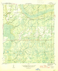
1945 Map of Woods
USGS Topo · Published 1945About this map
The small settlement of Woods anchors this 1945 survey of the Florida panhandle, situated at a junction near Telogia Creek. The landscape is dominated by the dense wetlands of the Juniper Swamp and the expansive Apalachicola National Forest, where a network of seasonal branches like Johnson Branch and Mill Branch feed into the winding New River. The map provides a detailed look at the rural infrastructure of Liberty County toward the end of the war, notably marking Smokehouse Crossing at a ford on Gully Creek. To the south, the terrain transitions into a series of distinctive lowland bays and ponds, including Buggar Bay, Shuler Bay, and Washington Bay, alongside isolated high ground such as Memery Island and Sheep Island. This mid-century view preserves the locations of remote family crossings and named water features that characterized the region before modern drainage and road development altered the hydrology.
Find a feature on this map
31 named features on this map. Tap any name to fly to it.
Don’t see what you’re looking for? This feature index may not catch every label — zoom into the map to look around manually.
Map Details
Editions of this 1945 Woods Map
4 editions found
Other maps of this area

1944 · Queens Bay
USGS Topo · 1:24,000

1945 · Blountstown
USGS Topo · 1:31,680

1945 · Hosford
USGS Topo · 1:31,680

1945 · Estiffanulga
USGS Topo · 1:31,680

1945 · Orange
USGS Topo · 1:31,680

1945 · Bristol
USGS Topo · 1:31,680

1945 · Woods
USGS Topo · 1:31,680

1945 · Telogia
USGS Topo · 1:24,000

1946 · Queens Bay
USGS Topo · 1:31,680

1946 · Telogia
USGS Topo · 1:31,680