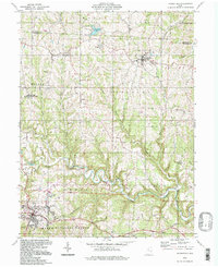
1994 Map of Woodsfield
USGS Topo · Published 1998About this map
Sunfish Creek meanders through the central hills of Monroe County, defining a landscape of steep ridges and deep hollows. The county seat at Woodsfield serves as the primary hub, where the Fairgrounds and Woodsfield Airport sit on the flatter western plateau. Outside the town centers, the map reveals a dense network of rural landmarks, from the Immaculate Conception Ch at Ozark to isolated burial grounds like Hood Ridge Cem and Gillespie Cem.
Find a feature on this map
49 named features on this map. Tap any name to fly to it.
Don’t see what you’re looking for? This feature index may not catch every label — zoom into the map to look around manually.
Map Details
Editions of this 1994 Woodsfield Map
This is the sole edition of this map. No revisions or reprints were ever made.
Other maps of this area

1905 · Clarington
USGS Topo · 1:62,500

1905 · New Matamoras
USGS Topo · 1:62,500

1905 · Woodsfield
USGS Topo · 1:62,500

1906 · New Martinsville
USGS Topo · 1:62,500

1924 · New Martinsville
USGS Topo · 1:62,500

1924 · New Matamoras
USGS Topo · 1:62,500

1926 · New Martinsville
USGS Topo · 1:62,500

1926 · New Matamoras
USGS Topo · 1:62,500

1935 · Clarington
USGS Topo · 1:62,500

1940 · Clarington
USGS Topo · 1:62,500