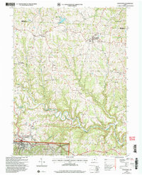
2002 Map of Woodsfield
USGS Topo · Published 2006About this map
Woodsfield serves as the focal point of this Monroe County landscape, where the plateau terrain is deeply incised by the drainage of Sunfish Creek and its many tributaries. The area reflects a late-twentieth-century transition between traditional agriculture and resource extraction, evidenced by the numerous Gas Wells and an active Strip Mine near Coats. Local history is anchored by rural institutions like Immaculate Conception Ch and Ashbury Chapel, while the Fairgrounds and Woodsfield Airport mark the community's more modern infrastructure.
Find a feature on this map
53 named features on this map. Tap any name to fly to it.
Don’t see what you’re looking for? This feature index may not catch every label — zoom into the map to look around manually.
Map Details
Editions of this 2002 Woodsfield Map
This is the sole edition of this map. No revisions or reprints were ever made.
Other maps of this area

1905 · Clarington
USGS Topo · 1:62,500

1905 · New Matamoras
USGS Topo · 1:62,500

1905 · Woodsfield
USGS Topo · 1:62,500

1906 · New Martinsville
USGS Topo · 1:62,500

1924 · New Martinsville
USGS Topo · 1:62,500

1924 · New Matamoras
USGS Topo · 1:62,500

1926 · New Martinsville
USGS Topo · 1:62,500

1926 · New Matamoras
USGS Topo · 1:62,500

1935 · Clarington
USGS Topo · 1:62,500

1940 · Clarington
USGS Topo · 1:62,500