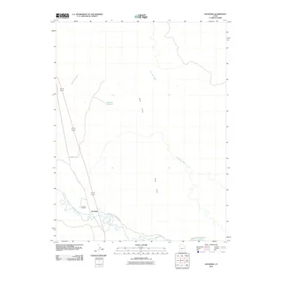
2011 Map of Woodside
USGS Topo · Published 2011About this map
The Woodside settlement and the meandering Price River define this corner of Emery County, where the desert landscape meets the dramatic rise of the Book Cliffs. This 2011 survey illustrates a quiet stretch of eastern Utah, centered on a small community footprint and the nearby Woodside Cemetery. The area’s water management is evident in features like Kiahtipes Reservoir and the network of seasonal drainages, including Marsh Flat Wash and Little Park Wash, that carve through the arid terrain. Regional access is provided by County Rd 128 and the Woodside Lower Price River Rd, which follow the natural contours of the river valley. The map provides a clear view of the rural infrastructure and landmarks that remain significant to local genealogy and the historical geography of the Price River drainage.
Find a feature on this map
9 named features on this map. Tap any name to fly to it.
Don’t see what you’re looking for? This feature index may not catch every label — zoom into the map to look around manually.
Map Details
Editions of this 2011 Woodside Map
This is the sole edition of this map. No revisions or reprints were ever made.
Other maps of this area

1886 · Price River
USGS Topo · 1:250,000

1896 · Price River
USGS Topo · 1:250,000

1948 · Woodside
USGS Topo · 1:62,500

1949 · Woodside
USGS Topo · 1:62,500

1950 · Woodside
USGS Topo · 1:62,500

1954 · Range Creek
USGS Topo · 1:62,500

1956 · Price
USGS Topo · 1:250,000

1960 · Price
USGS Topo · 1:250,000

1962 · Price
USGS Topo · 1:250,000
1963 · Gunnison Butte
USGS Topo · 1:62,500