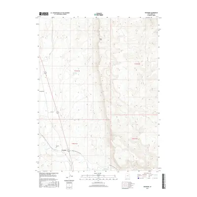
2017 Map of Woodside
USGS Topo · Published 2017About this map
Woodside sits at the base of the dramatic Book Cliffs escarpment, where the high desert terrain meets the Price River. This 2017 survey details the geographical relationship between the small settlement and its vital water sources, including the Kiahtipes Reservoir and the drainage of Grassy Wash. The map traces the winding paths of rural infrastructure like Woodside Lower Price River Rd and Co Rd 128, which follow the natural contours of the river valley. For local historians and genealogists, the inclusion of the Woodside Cem provides a specific point of interest for family research. The landscape is defined by the sharp elevation changes of the cliffs to the east and the riparian corridor to the west, showing the persistent footprint of human habitation in a region shaped by arid environmental constraints.
Find a feature on this map
12 named features on this map. Tap any name to fly to it.
Don’t see what you’re looking for? This feature index may not catch every label — zoom into the map to look around manually.
Map Details
Editions of this 2017 Woodside Map
This is the sole edition of this map. No revisions or reprints were ever made.
Other maps of this area

1886 · Price River
USGS Topo · 1:250,000

1896 · Price River
USGS Topo · 1:250,000

1948 · Woodside
USGS Topo · 1:62,500

1949 · Woodside
USGS Topo · 1:62,500

1950 · Woodside
USGS Topo · 1:62,500

1954 · Range Creek
USGS Topo · 1:62,500

1956 · Price
USGS Topo · 1:250,000

1960 · Price
USGS Topo · 1:250,000

1962 · Price
USGS Topo · 1:250,000
1963 · Gunnison Butte
USGS Topo · 1:62,500