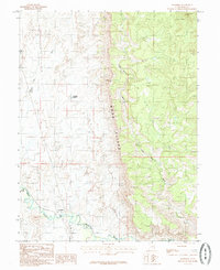
1985 Map of Woodside
USGS Topo · Published 1985About this map
Woodside sits at the base of the dramatic Book Cliffs in this mid-1980s topographic survey of Emery County. The settlement serves as a focal point where the D & R G W railroad aligns with the meandering course of the Price River. This corridor was essential for transportation through the arid Utah landscape, evidenced by the presence of a Cem and a Gaging Sta near the riverbanks. The surrounding terrain is defined by complex drainage systems, including Grassy Wash and Little Park Wash, which carve through the high plateaus and alluvial plains. Human water management in this desert environment is marked by features like the Kiahtipes Reservoir, while the broad expanse of Marsh Flat highlights the varied topography between the river valley and the towering cliff faces to the east.
Find a feature on this map
11 named features on this map. Tap any name to fly to it.
Don’t see what you’re looking for? This feature index may not catch every label — zoom into the map to look around manually.
Map Details
Editions of this 1985 Woodside Map
This is the sole edition of this map. No revisions or reprints were ever made.
Other maps of this area

1886 · Price River
USGS Topo · 1:250,000

1896 · Price River
USGS Topo · 1:250,000

1948 · Woodside
USGS Topo · 1:62,500

1949 · Woodside
USGS Topo · 1:62,500

1950 · Woodside
USGS Topo · 1:62,500

1954 · Range Creek
USGS Topo · 1:62,500

1956 · Price
USGS Topo · 1:250,000

1960 · Price
USGS Topo · 1:250,000

1962 · Price
USGS Topo · 1:250,000
1963 · Gunnison Butte
USGS Topo · 1:62,500