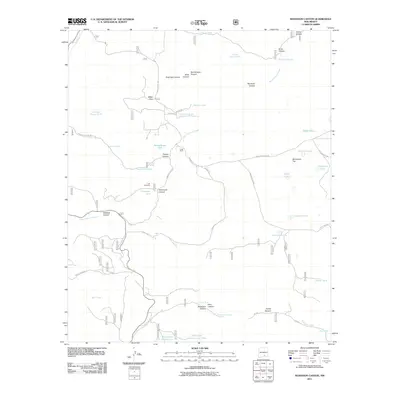
2011 Map of Woodson Canyon
USGS Topo · Published 2011About this map
Lusk Cemetery and the Lewis Ranch anchor this Otero County landscape, where the high-desert drainage system of the Sacramento Mountains is meticulously documented. The terrain is defined by a dense network of canyons, including Woodson Canyon, McEwan Canyon, and Graveyard Canyon, which feed into primary watercourses like Agua Chiquita Creek and the Rio Peñasco. This 2011 survey reveals an environment where water management is central to land use, evidenced by the numerous named tanks such as Schoolhouse Tank, Prather Tank, and Section Eleven Tank. These features, alongside Miller Flats and McDonald Flat, suggest a history of ranching and remote settlement. Transportation is facilitated by primitive routes like Miller Flats Rd and McDonald Flats Rd, connecting isolated lakes like Barkley Lake and Wilson Lake across the arid topography.
Find a feature on this map
51 named features on this map. Tap any name to fly to it.
Don’t see what you’re looking for? This feature index may not catch every label — zoom into the map to look around manually.
Map Details
Editions of this 2011 Woodson Canyon Map
This is the sole edition of this map. No revisions or reprints were ever made.
Other maps of this area

1952 · Cloudcroft
USGS Topo · 1:62,500

1954 · Carlsbad
USGS Topo · 1:250,000

1958 · Carlsbad
USGS Topo · 1:250,000

1963 · Mayhill
USGS Topo · 1:24,000

1963 · Robertson Canyon
USGS Topo · 1:24,000

1963 · Woodson Canyon
USGS Topo · 1:24,000
1963 · Elk
USGS Topo · 1:24,000

1965 · Chimney Lake
USGS Topo · 1:24,000

1965 · Bear Spring
USGS Topo · 1:24,000

1965 · Avis
USGS Topo · 1:24,000