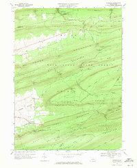
1968 Map of Woodward
USGS Topo · Published 1971About this map
Woodward sits at the base of Winkelblech Mountain in this late 1960s study of Central Pennsylvania’s ridge-and-valley province. The landscape is defined by the steep, parallel rises of Brush Mountain, Hough Mountain, and Buffalo Mountain, most of which fall under the stewardship of the Bald Eagle State Forest. Movement through this high-relief terrain is dictated by a series of narrow passages, including Wolfs Store Gap and Winkelblech Gap, while the valley floors support small settlements like Livonia and Voneida. Drainage patterns are equally constrained by the geology, with Elk Creek and Pine Creek threading through the lowlands. Notable local landmarks like the Radio Tower Woodward and the curiously named Cinder Pile Spring provide specific points of reference for those tracing the development and land-use patterns of the Penns Valley region during this era.
Find a feature on this map
69 named features on this map. Tap any name to fly to it.
Don’t see what you’re looking for? This feature index may not catch every label — zoom into the map to look around manually.
Map Details
Editions of this 1968 Woodward Map
3 editions found
Other maps of this area

1921 · Williamsport
USGS Topo · 1:48,000

1921 · Lock Haven
USGS Topo · 1:62,500

1923 · Lock Haven
USGS Topo · 1:62,500

1923 · Williamsport
USGS Topo · 1:62,500

1937 · Millheim
USGS Topo · 1:48,000

1938 · Mifflinburg
USGS Topo · 1:48,000

1941 · Millheim
USGS Topo · 1:62,500

1943 · Mifflinburg
USGS Topo · 1:62,500

1944 · Williamsport
USGS Topo · 1:62,500

1944 · Lock Haven
USGS Topo · 1:62,500