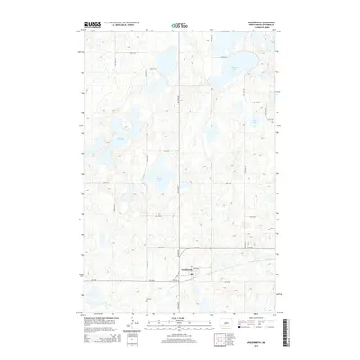
2014 Map of Woodworth
USGS Topo · Published 2014About this map
Woodworth sits at the southern edge of this Stutsman County landscape, serving as a concentrated point of settlement amidst a vast network of prairie potholes and wetlands. The town's layout is clearly defined by local thoroughfares like 1st Ave W and 4th Ave Ne, featuring a central Po and the nearby Gem Cem to the southwest. The geography is dominated by numerous glacial lakes, including the large Barnes Lake in the northeast and the centrally located Sunday Lake. This 2014 survey illustrates the persistence of the section-line road grid, where routes such as Hy 36 SE and 56th Ave SE navigate around significant water bodies like Meander Lake and Colby Lake. The map provides a detailed view of the North Dakota prairie's hydrography, showing how local transportation and rural land use have adapted to the natural contours of the wetland-rich terrain.
Find a feature on this map
26 named features on this map. Tap any name to fly to it.
Don’t see what you’re looking for? This feature index may not catch every label — zoom into the map to look around manually.
Map Details
Editions of this 2014 Woodworth Map
This is the sole edition of this map. No revisions or reprints were ever made.
Other maps of this area

1948 · Carrington
USGS Topo · 1:62,500

1950 · Carrington SW
USGS Topo · 1:24,000

1952 · New Rockford
USGS Topo · 1:250,000

1956 · New Rockford
USGS Topo · 1:250,000
1958 · Goldwin SW
USGS Topo · 1:24,000

1958 · Goldwin
USGS Topo · 1:24,000

1971 · New Rockford
USGS Topo · 1:250,000

1972 · Woodworth
USGS Topo · 1:24,000
1972 · Lake Louise
USGS Topo · 1:24,000
1972 · Pearl Lake
USGS Topo · 1:24,000