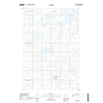
2018 Map of Woodworth
USGS Topo · Published 2018About this map
Woodworth anchors this prairie landscape, situated near the southern edge of a glaciated terrain defined by numerous small water bodies and seasonal wetlands. The town's grid is small but distinct, positioned at the intersection of local routes like 4th Ave NE and 1st Ave W. North of the settlement, the geography is dominated by Barnes Lake, Colby Lake, and Sunday Lake, which are part of a dense cluster of prairie potholes typical of this portion of Stutsman County. To the southwest, the Gem Cem serves as a significant genealogical landmark for the surrounding rural township. The map illustrates a disciplined section-line road network, including 54th Ave SE and 17th St SE, which provide access to the agricultural lands between these scattered lakes and marshes.
Find a feature on this map
27 named features on this map. Tap any name to fly to it.
Don’t see what you’re looking for? This feature index may not catch every label — zoom into the map to look around manually.
Map Details
Editions of this 2018 Woodworth Map
This is the sole edition of this map. No revisions or reprints were ever made.
Other maps of this area

1948 · Carrington
USGS Topo · 1:62,500

1950 · Carrington SW
USGS Topo · 1:24,000

1952 · New Rockford
USGS Topo · 1:250,000

1956 · New Rockford
USGS Topo · 1:250,000
1958 · Goldwin SW
USGS Topo · 1:24,000

1958 · Goldwin
USGS Topo · 1:24,000

1971 · New Rockford
USGS Topo · 1:250,000

1972 · Woodworth
USGS Topo · 1:24,000
1972 · Lake Louise
USGS Topo · 1:24,000
1972 · Pearl Lake
USGS Topo · 1:24,000