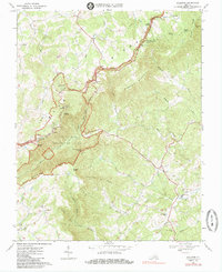
1968 Map of Woolwine
USGS Topo · Published 1986About this map
The Blue Ridge Parkway meanders along the crest of the Blue Ridge in this 1968 survey, tracing the border between Floyd and Patrick counties. This high-country landscape is defined by its prominent summits, including Rocky Knob, Panther Knob, and Twelve O'clock Knob, all within the Rocky Knob Recreation Area. This region preserved a distinct mountain-rural character late into the twentieth century, with family-centered landmarks like Rakes Millpond and scattered congregations such as Fairview Ch and Thomas Grove Ch anchoring the high gaps. In the valleys below, the Smith River and Jill Creek provide the primary drainage for small settlements like Woolwine and Tuggle Gap. Genealogists will find a high density of rural cemeteries and country churches, including Jacks Creek Ch and West Liberty Ch, which speak to the area's deep-rooted community structure.
Find a feature on this map
45 named features on this map. Tap any name to fly to it.
Don’t see what you’re looking for? This feature index may not catch every label — zoom into the map to look around manually.
Map Details
Editions of this 1968 Woolwine Map
2 editions found
Other maps of this area

1926 · Critz
USGS Topo · 1:48,000

1928 · Stuart
USGS Topo · 1:48,000

1928 · Critz
USGS Topo · 1:62,500

1931 · Stuart
USGS Topo · 1:62,500

1953 · Winston-Salem
USGS Topo · 1:250,000

1955 · Winston-Salem
USGS Topo · 1:250,000

1957 · Endicott
USGS Topo · 1:62,500

1957 · Floyd
USGS Topo · 1:62,500

1962 · Winston-Salem
USGS Topo · 1:250,000

1967 · Patrick Springs
USGS Topo · 1:24,000