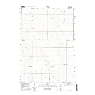
2015 Map of Woonsocket NW
USGS Topo · Published 2015About this map
Alpena occupies the eastern edge of this agricultural landscape at the border of Beadle and Jerauld counties. The terrain is defined by a strictly surveyed section-line road grid, including 220th St and 389th Ave, which organizes the high plains farmland. This 2015 survey reflects a rural interior punctuated by subtle watercourses such as Sand Creek, which meanders through the central and southern portions of the quadrangle. Genealogists can locate Zion Cemetery situated near the intersection of 220th St and 389th Ave, a common placement for burial grounds in the prairie township system. In the southwestern corner, Firesteel Creek cuts across the grid, representing the few breaks in the vast, level topography typical of this part of South Dakota.
Find a feature on this map
24 named features on this map. Tap any name to fly to it.
Don’t see what you’re looking for? This feature index may not catch every label — zoom into the map to look around manually.
Map Details
Editions of this 2015 Woonsocket NW Map
This is the sole edition of this map. No revisions or reprints were ever made.
Other maps of this area

1898 · Huron
USGS Topo · 1:125,000

1951 · Wessington SE
USGS Topo · 1:24,000

1953 · Huron
USGS Topo · 1:250,000

1954 · Huron
USGS Topo · 1:250,000

1973 · Alpena
USGS Topo · 1:24,000

1973 · Wessington Springs NE
USGS Topo · 1:24,000
1973 · Woonsocket
USGS Topo · 1:24,000

1973 · Wessington Springs
USGS Topo · 1:24,000
1973 · Virgil
USGS Topo · 1:24,000
1973 · Woonsocket NW
USGS Topo · 1:24,000