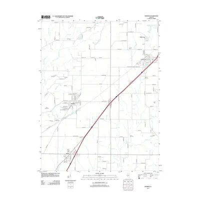
2012 Map of Worden
USGS Topo · Published 2012About this map
The agrarian and industrial landscape of Madison and Macoupin counties is anchored by the village of Worden and the neighboring towns of Livingston and Hamel. Historically defined by its proximity to coal resources, as evidenced by the Mount Olive Staunton Coal Company Reservoir in the northeast, the area is crisscrossed by a network of rural routes and the modern Interstate corridors. The map reveals a dense distribution of local burial grounds and religious landmarks, including the Hoxsey Family Cem, Saint Paul Lutheran Cem, and Salem Evangelical Cem. Along the western edge, the meandering courses of Cahokia Cr and its W Fork Cahokia Cr contrast with the rectilinear township and range grid. Unique local landmarks like Opel's Fish Hatchery and Meadow View Gardens reflect the specialized agricultural and commercial heritage of this Illinois region.
Find a feature on this map
119 named features on this map. Tap any name to fly to it.
Don’t see what you’re looking for? This feature index may not catch every label — zoom into the map to look around manually.
Map Details
Editions of this 2012 Worden Map
This is the sole edition of this map. No revisions or reprints were ever made.
Other maps of this area

1912 · Gillespie
USGS Topo · 1:62,500

1915 · Gillespie
USGS Topo · 1:62,500

1915 · Mount Olive
USGS Topo · 1:62,500

1927 · Edwardsville
USGS Topo · 1:62,500

1932 · Edwardsville
USGS Topo · 1:62,500

1937 · New Douglas
USGS Topo · 1:48,000

1944 · New Douglas
USGS Topo · 1:62,500

1944 · Mount Olive
USGS Topo · 1:62,500

1950 · Edwardsville
USGS Topo · 1:24,000
1954 · Marine
USGS Topo · 1:24,000