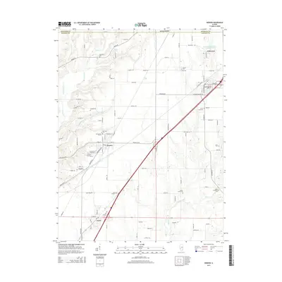
2015 Map of Worden
USGS Topo · Published 2015About this map
Hamel and Worden anchor the southern reach of this Illinois landscape, where the agricultural plains are deeply etched by the drainage of Cahokia Cr and Silver Cr. The presence of the Mount Olive Staunton Coal Company Reservoir near Williamson and Old Coal Mine Rd south of Livingston reflects the regional reliance on coal mining and industrial infrastructure. The map is particularly notable for its dense network of rural burial sites, including the Hoxey Family Cem and the Gehlenback Lutheran Cem, which serve as vital markers of early community identity. From the residential streets of Meadow View Gardens to the natural rise of Possum Hill, the terrain shows a clear transition from developed corridors to the sprawling creek-fed valleys that define the Madison Co and Macoupin Co border.
Find a feature on this map
102 named features on this map. Tap any name to fly to it.
Don’t see what you’re looking for? This feature index may not catch every label — zoom into the map to look around manually.
Map Details
Editions of this 2015 Worden Map
This is the sole edition of this map. No revisions or reprints were ever made.
Other maps of this area

1912 · Gillespie
USGS Topo · 1:62,500

1915 · Gillespie
USGS Topo · 1:62,500

1915 · Mount Olive
USGS Topo · 1:62,500

1927 · Edwardsville
USGS Topo · 1:62,500

1932 · Edwardsville
USGS Topo · 1:62,500

1937 · New Douglas
USGS Topo · 1:48,000

1944 · New Douglas
USGS Topo · 1:62,500

1944 · Mount Olive
USGS Topo · 1:62,500

1950 · Edwardsville
USGS Topo · 1:24,000
1954 · Marine
USGS Topo · 1:24,000