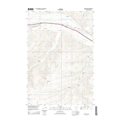
2014 Map of Work Creek
USGS Topo · Published 2014About this map
The Yellowstone River cuts through the northern portion of this Sweet Grass County landscape, paralleled by a corridor of transportation history including the modern interstate and Old US-10. Near the river, small settlements like Quebec and The Greycliffs are situated amidst a network of irrigation and local transit, notably the Kent Ditch. To the south, the terrain becomes increasingly complex, defined by a series of drainages such as Bridger Cr and Work Cr, and named topographic features like Shanks Basin and Norwegian Gulch.
Find a feature on this map
24 named features on this map. Tap any name to fly to it.
Don’t see what you’re looking for? This feature index may not catch every label — zoom into the map to look around manually.
Map Details
Editions of this 2014 Work Creek Map
This is the sole edition of this map. No revisions or reprints were ever made.
Other maps of this area

1891 · Big Timber
USGS Topo · 1:125,000

1893 · Big Timber
USGS Topo · 1:125,000

1954 · Billings
USGS Topo · 1:250,000

1955 · Packsaddle Butte
USGS Topo · 1:24,000

1955 · Sandborn Creek
USGS Topo · 1:24,000

1955 · Reed Point
USGS Topo · 1:24,000
1955 · Wildcat Draw
USGS Topo · 1:24,000

1955 · Greycliff
USGS Topo · 1:24,000
1955 · Cow Face Hill
USGS Topo · 1:24,000

1955 · Stephens Hill
USGS Topo · 1:24,000