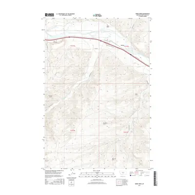
2017 Map of Work Creek
USGS Topo · Published 2017About this map
The Yellowstone River cuts through the northern portion of this landscape, accompanied by the engineering of the Kent Ditch and the small settlement at Quebec. This Sweet Grass County terrain is defined by a series of significant drainage systems and named topographic depressions, including Norwegian Gulch, Tom Benson Gulch, and Big Spring Gulch south of the river. The southern portion of the sheet is largely undeveloped, marked primarily by ranch roads like Work Creek Rd and the winding course of Work Cr. Local history is anchored by the Kent Cem, situated near the confluence of Bridger Cr and the river. Notable geological formations like The Greycliffs and Shanks Basin provide a clear view of the area's physical geography as it stood in the early 21st century, showing the persistence of traditional Montana water-management and ranching patterns.
Find a feature on this map
26 named features on this map. Tap any name to fly to it.
Don’t see what you’re looking for? This feature index may not catch every label — zoom into the map to look around manually.
Map Details
Editions of this 2017 Work Creek Map
This is the sole edition of this map. No revisions or reprints were ever made.
Other maps of this area

1891 · Big Timber
USGS Topo · 1:125,000

1893 · Big Timber
USGS Topo · 1:125,000

1954 · Billings
USGS Topo · 1:250,000

1955 · Packsaddle Butte
USGS Topo · 1:24,000

1955 · Sandborn Creek
USGS Topo · 1:24,000

1955 · Reed Point
USGS Topo · 1:24,000
1955 · Wildcat Draw
USGS Topo · 1:24,000

1955 · Greycliff
USGS Topo · 1:24,000
1955 · Cow Face Hill
USGS Topo · 1:24,000

1955 · Stephens Hill
USGS Topo · 1:24,000