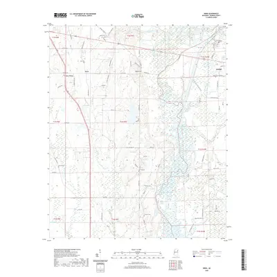
2020 Map of Wren
USGS Topo · Published 2020About this map
Wren and New Wren anchor the northwestern portion of this Monroe County landscape, characterized by a series of engineered watercourses and traditional rural settlements. The eastern edge of the map features the outskirts of Amory and the Tombigbee River, where the natural flow is modified by several significant navigational improvements. These include the Roundhouse Branch Cutoff, Becker Cutoff, and Acker Lake Cutoff, which illustrate the modern management of the river system. Between the hills and the river bottomlands, the map records a high density of local cemeteries, including Wren Cem, Bransford Cem, and New Hope Cem, which serve as vital landmarks for genealogical research. Prominent local relief such as Colberts Hill rises above the drainage of Town Creek and Wolf Cr, while Lake Martha provides a distinct interior water feature amidst the intersection of old transport routes like Old Hwy 41 and Old Wren Rd.
Find a feature on this map
86 named features on this map. Tap any name to fly to it.
Don’t see what you’re looking for? This feature index may not catch every label — zoom into the map to look around manually.
Map Details
Editions of this 2020 Wren Map
This is the sole edition of this map. No revisions or reprints were ever made.
Other maps of this area

1953 · West Point
USGS Topo · 1:250,000

1956 · Tupelo
USGS Topo · 1:250,000

1958 · Tupelo
USGS Topo · 1:250,000

1958 · West Point
USGS Topo · 1:250,000

1963 · West Point
USGS Topo · 1:250,000

1965 · Egypt
USGS Topo · 1:24,000

1966 · Smithville
USGS Topo · 1:24,000

1966 · Aberdeen
USGS Topo · 1:24,000

1966 · Shannon
USGS Topo · 1:24,000

1966 · Amory
USGS Topo · 1:24,000
Featured Places
- Amory, MS
- Lake Monroe West Subdivision, MS
- Lake Monroe East Subdivision, MS
- New Wren, MS
- Cotton Hill Gin Estates, MS