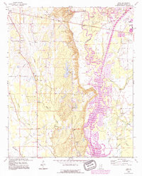
1992 Map of Wren
USGS Topo · Published 1995About this map
The Tennessee Tombigbee Waterway defines the eastern landscape of this Monroe County region, showcasing the significant engineering of the canalized river system. The map records the historical footprint of the Old Indian Treaty Boundary, which cuts diagonally across the northern terrain near Burketts. This line provides a clear spatial reference for the early division of land in Mississippi. West of the river, the settlements of Wren and New Wren serve as focal points for a network of rural roads connecting numerous family and community landmarks.
Find a feature on this map
47 named features on this map. Tap any name to fly to it.
Don’t see what you’re looking for? This feature index may not catch every label — zoom into the map to look around manually.
Map Details
Editions of this 1992 Wren Map
This is the sole edition of this map. No revisions or reprints were ever made.
Other maps of this area

1953 · West Point
USGS Topo · 1:250,000

1956 · Tupelo
USGS Topo · 1:250,000

1958 · Tupelo
USGS Topo · 1:250,000

1958 · West Point
USGS Topo · 1:250,000

1963 · West Point
USGS Topo · 1:250,000

1965 · Egypt
USGS Topo · 1:24,000

1966 · Smithville
USGS Topo · 1:24,000

1966 · Aberdeen
USGS Topo · 1:24,000

1966 · Shannon
USGS Topo · 1:24,000

1966 · Amory
USGS Topo · 1:24,000