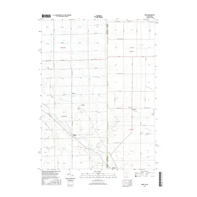
2016 Map of Wren
USGS Topo · Published 2016About this map
The Saint Marys River winds through this borderland region, anchoring the small communities of Pleasant Mills and Willshire in Indiana and Ohio. This 2016 survey details the geometric grid of agricultural roads that define the landscape, where family history is etched into the many rural burial grounds like Salem Cem and Fletcher Cem. The town of Wren serves as a local hub near the Ohio-Indiana State Line Rd, reflecting the enduring settlement patterns of the Midwest. Genealogists will find particular value in the distinction between Mount Tabor Cem and the Old Mount Tabor Cem, indicating shifts in the local community over generations. Smaller watercourses such as Blue Creek and Yellow Cr drain the flat plains, while named ditches like Bowen Ditch illustrate the long-standing management of these fertile lands.
Find a feature on this map
116 named features on this map. Tap any name to fly to it.
Don’t see what you’re looking for? This feature index may not catch every label — zoom into the map to look around manually.
Map Details
Editions of this 2016 Wren Map
This is the sole edition of this map. No revisions or reprints were ever made.
Other maps of this area

1911 · Berne
USGS Topo · 1:48,000

1914 · Celina
USGS Topo · 1:62,500

1914 · Van Wert
USGS Topo · 1:62,500

1944 · Van Wert
USGS Topo · 1:62,500

1944 · Celina
USGS Topo · 1:62,500

1953 · Muncie
USGS Topo · 1:250,000

1956 · Muncie
USGS Topo · 1:250,000
1960 · Convoy
USGS Topo · 1:24,000

1960 · Dixon
USGS Topo · 1:24,000
1960 · Rockford
USGS Topo · 1:24,000