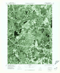
1977 Map of Wrentham
USGS Topo · Published 1981About this map
Wrentham and the surrounding Norfolk County landscape appear in high detail on this 1977 orthophotoquad, which uses rectified aerial imagery to reveal the physical reality of the Massachusetts terrain. This specific format provides an unfiltered look at the mid-to-late 1970s development patterns, showing the dense clusters of Norfolk and Foxboro contrasted against the darker texture of wetlands and forested parcels. The photograph allows researchers to trace the exact footprint of residential expansion and the winding corridors of the Mill River and Ten Mile River.
Find a feature on this map
9 named features on this map. Tap any name to fly to it.
Don’t see what you’re looking for? This feature index may not catch every label — zoom into the map to look around manually.
Map Details
Editions of this 1977 Wrentham Map
This is the sole edition of this map. No revisions or reprints were ever made.
Other maps of this area

1885 · Taunton
USGS Topo · 1:62,500

1886 · Dedham
USGS Topo · 1:62,500

1887 · Franklin
USGS Topo · 1:62,500

1887 · Providence
USGS Topo · 1:62,500

1888 · Taunton
USGS Topo · 1:62,500

1889 · Providence
USGS Topo · 1:62,500

1889 · Franklin
USGS Topo · 1:62,500

1893 · Taunton
USGS Topo · 1:62,500

1893 · Franklin
USGS Topo · 1:62,500

1894 · Dedham
USGS Topo · 1:62,500