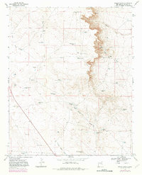
1967 Map of Wright Ranch
USGS Topo · Published 1982About this map
Wright Ranch and its surrounding water infrastructure define this high-desert landscape in De Baca County, where the management of scarce resources shaped local ranching life. The area is marked by a complex network of stock tanks and wells, including High Lonesome Windmill and family-named landmarks like Panama Martin Tank and Berts Well. These features were vital for survival in an environment where intermittent drainages like Ragland Draw, Indian Draw, and Burro Draw only briefly held water.
Find a feature on this map
41 named features on this map. Tap any name to fly to it.
Don’t see what you’re looking for? This feature index may not catch every label — zoom into the map to look around manually.
Map Details
Editions of this 1967 Wright Ranch Map
2 editions found
Other maps of this area

1954 · Fort Sumner
USGS Topo · 1:250,000

1958 · Fort Sumner
USGS Topo · 1:250,000

1966 · El Morro Mesa
USGS Topo · 1:24,000

1967 · Wire Lake
USGS Topo · 1:24,000

1967 · Devils Well
USGS Topo · 1:24,000

1967 · Ramon
USGS Topo · 1:24,000

1967 · Ramon SW
USGS Topo · 1:24,000
1967 · The Old Dry Lake
USGS Topo · 1:24,000

1967 · Wright Ranch
USGS Topo · 1:24,000

1979 · Fort Sumner
USGS Topo · 1:100,000